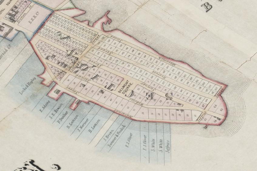
When we left off last time, it was 1837, and Jeffries Point was a sparsely settled spit of land in the middle of Boston Harbor. The East Boston Company was busy filling in marshland, laying out a grid of wide, straight streets, and trying to convince investors and real estate developers to buy into the new neighborhood. They had big plans for the area, but by 1837, they’d only managed to convince a handful of people to build homes in Jeffries Point. This 1837 map shows just how empty the neighborhood was:
No one was sure how the fledgling neighborhood would develop, or whether it would succeed at all. At the time, the East Boston Company had two competing visions of the neighborhood’s future. On the one hand, they saw East Boston as a future center of commerce and industry – an urban neighborhood, densely settled with factories, piers, shipyards, and housing for working and middle class families. On the other hand, they were marketing the neighborhood as a sparsely-settled, upscale, resort community where wealthy Bostonians could build fancy summer homes to take advantage of the island’s cool sea breezes and harbor views, all within a short steamboat ride of downtown. It’s unclear whether the East Boston Company actually thought that these two visions of the neighborhood were compatible, or whether they simply decided to pursue both development strategies simultaneously to hedge their bets.
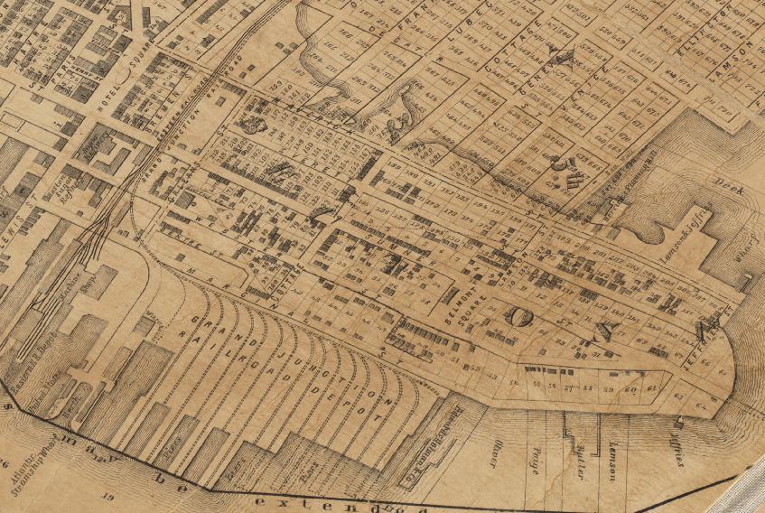
Either way, if we fast forward to 1851, it becomes clear which strategy won out.
In just 14 years, Jeffries Point had become a radically different place. Hundreds of new houses – represented by dark gray rectangles on the map – had been constructed one after the next across the neighborhood. Landfill operations and construction of new piers had nearly doubled the neighborhood’s usable land area. And a new railroad connected the Jeffries Point waterfront to Salem and other towns to the north. Although it never really took off as a summer resort community, the neighborhood was booming.
In many ways, Jeffries Point’s rapid success was a result of its geography. The neighborhood’s southern waterfront not only faces downtown Boston across the harbor, it’s also situated along a natural deep water channel that can accommodate large ships. The East Boston Company and early investors in the neighborhood capitalized on this natural shipping channel by constructing large piers, shipyards, and warehouses along the waterfront.
Their timing couldn’t have been better. In the late 1840s, just as development in Jeffries Point was taking off, the California Gold Rush began. As tens of thousands of people from around the world descended on the California goldfields, demand spiked for fast transportation of goods and people from the East Coast to California and back. Since the first transcontinental railroad wouldn’t be completed for another 20 years, most of this demand was met by ships sailing the ‘Golden Route’ around the bottom of South America and up the west coast to San Francisco. And with direct access to a deep water shipping channel and plenty of room to expand, the new port along the East Boston waterfront happened to be well-positioned to exploit this new demand for shipping.
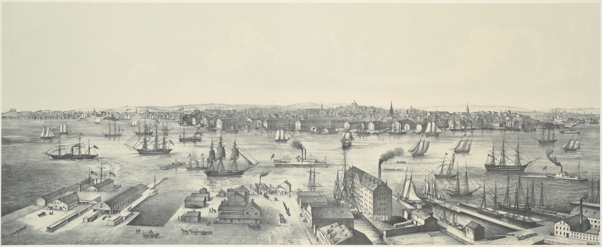
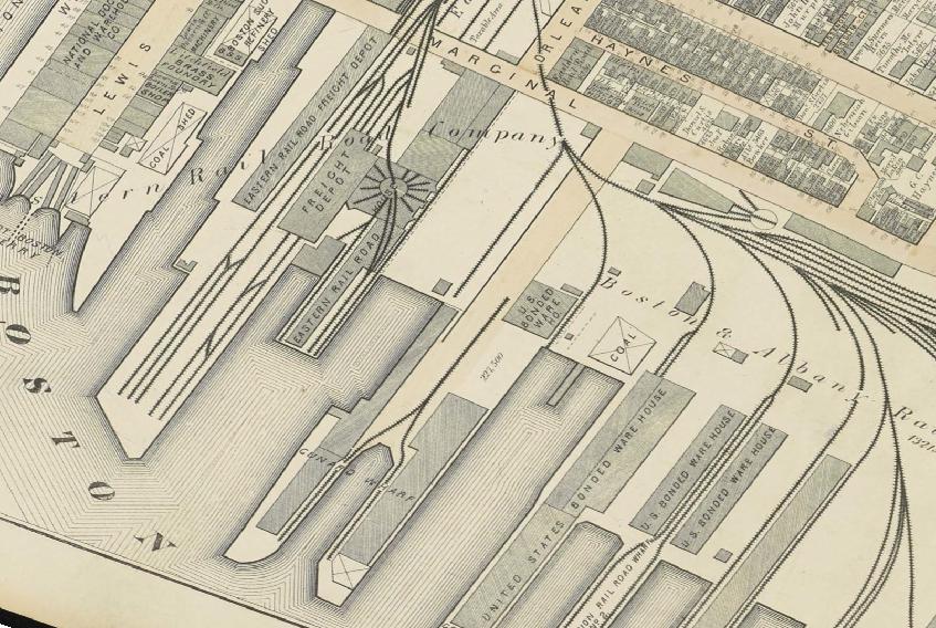
As shipyards, machine shops, warehouses, and shipping terminals sprung up along the Jeffries Point waterfront, hundreds of workers moved to the neighborhood. And since these workers needed a place to live, developers built hundreds of new houses. In 1851, most of these new houses were concentrated along the southern and western edges of the neighborhood, within easy walking distance of the booming waterfront. This 1848 engraving gives a sense of what the Jeffries Point waterfront looked like at the time (in the foreground):
The East Boston Company originally laid out lots in a variety of sizes designed to accommodate different types of housing – dense, affordable houses on smaller lots, and expensive suburban estates and summer homes on larger lots. But by 1851, the neighborhood had begun to look fairly uniform, with row after row of narrow, closely-spaced houses built across small and large lots alike. Looking at the map, it’s almost as if the original lot lines had begun to disappear. As with so many things, the reason for this change was money.
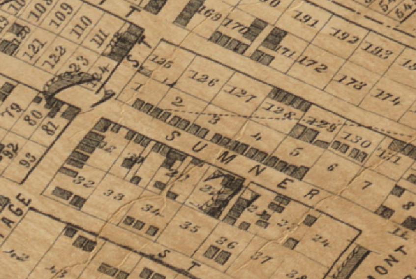
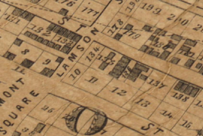
Faced with skyrocketing demand for new housing, real estate developers and many of the neighborhood’s land owners decided to cash in. They maximized the value of their land by subdividing the original lots, squeezing as many as five houses side-by-side along the front of a single lot. By 1851, Sumner Street was lined with small, narrow houses.
Some developers even constructed a second row of houses directly behind the first, along the rear property line, accessible only by walking through the narrow gaps between street-facing houses. In a time before zoning codes existed, developers ignored the fire and safety risks that come with this kind of ultra-dense, inaccessible development. Even so, many of these rear-lot houses survive today.
Other developers took advantage of the neighborhood’s deep lots by running dead-end alleyways between some of the larger lots. These private alleyways provided access to the rear of the lot, allowing developers to build tightly packed houses along the lot’s entire depth. Located in lot 136, Hooten Court was an early example of this kind of development.
Modern apartment buildings didn’t exist in the 1840s, but these private alleyways, lined with small workers’ cottages built one after the next, served a similar purpose, providing dense, affordable housing for urban, working families. A number of these alleyways still exist in Jeffries Point, several with their original houses intact. Over the years, these clusters of small houses have fostered close-knit communities, miniature neighborhoods within the larger Jeffries Point.
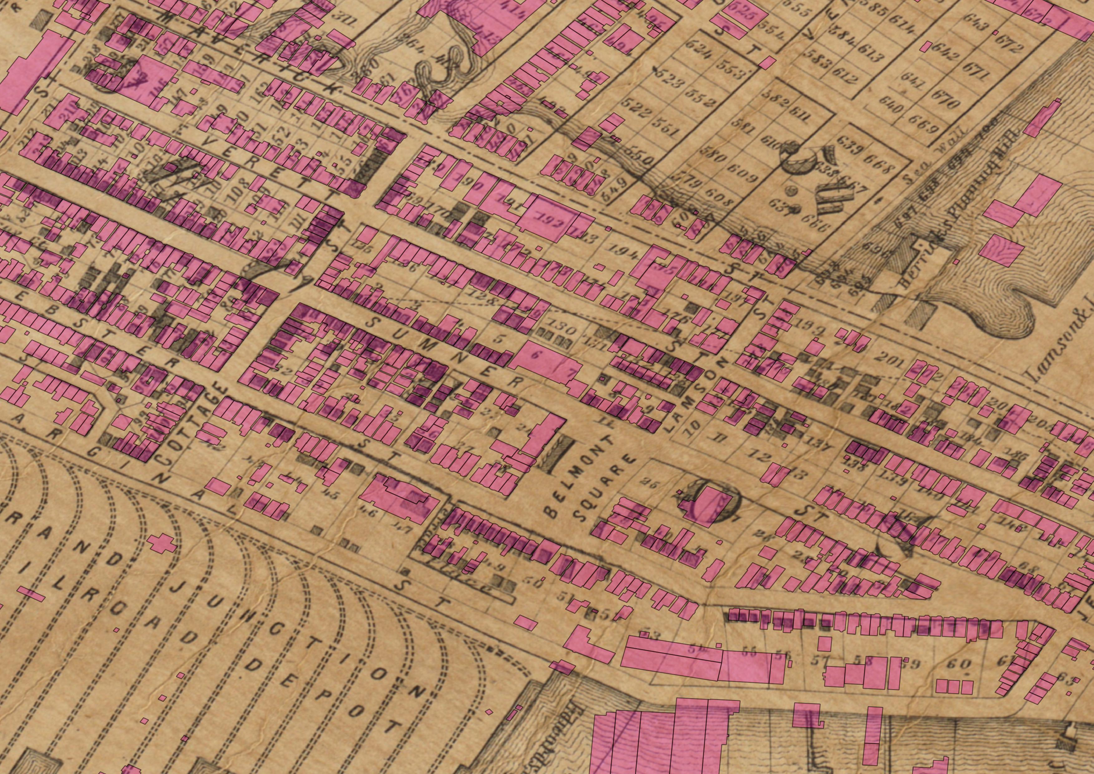
Jeffries Point in 1851 was an emerging neighborhood of narrow, tightly-spaced houses, many occupying just 20-25 feet of street frontage. Even though there was plenty of open space left, the neighborhood had taken on a definite urban character. If we overlay a map of the neighborhood’s current buildings (in pink) over the 1851 map, it immediately becomes clear that most of the houses that existed in 1851 still exist today (click the map to expand). A few of the houses have been demolished or replaced, and others have been added on to – rear additions are particularly common – but, amazingly, the majority of these 166-plus-year-old houses are still standing.
If we fast forward another 23 years to 1874, the East Boston Company’s luck had held, and the neighborhood had continued to expand.
Through the 1850s and into the 1860s, this growth was again fueled by the demand for shipping created by the California Gold Rush and the country’s westward expansion. Beginning in the 1840s, several young shipbuilders set up shipyards along the East Boston waterfront. Up until this time, shipbuilding had been more art than science, often relying on inherited traditions and guesswork. These new East Boston shipbuilders were some of the first to introduce scientific rigor and evidence-based engineering to their craft. During the two decades between 1850 and 1870, East Boston shipyards produced some of the fastest and most technologically advanced wooden sailing ships ever built, ushering in the golden age of the clippership.
Shipwrights, carpenters, sailmakers, and other skilled artisans, many of them from the Canadian Maritime Provinces, moved to the neighborhood in droves to work in East Boston’s world-renowned shipyards. As housing was constructed across Jeffries Point for this rapidly growing workforce, the neighborhood continued to become more dense.
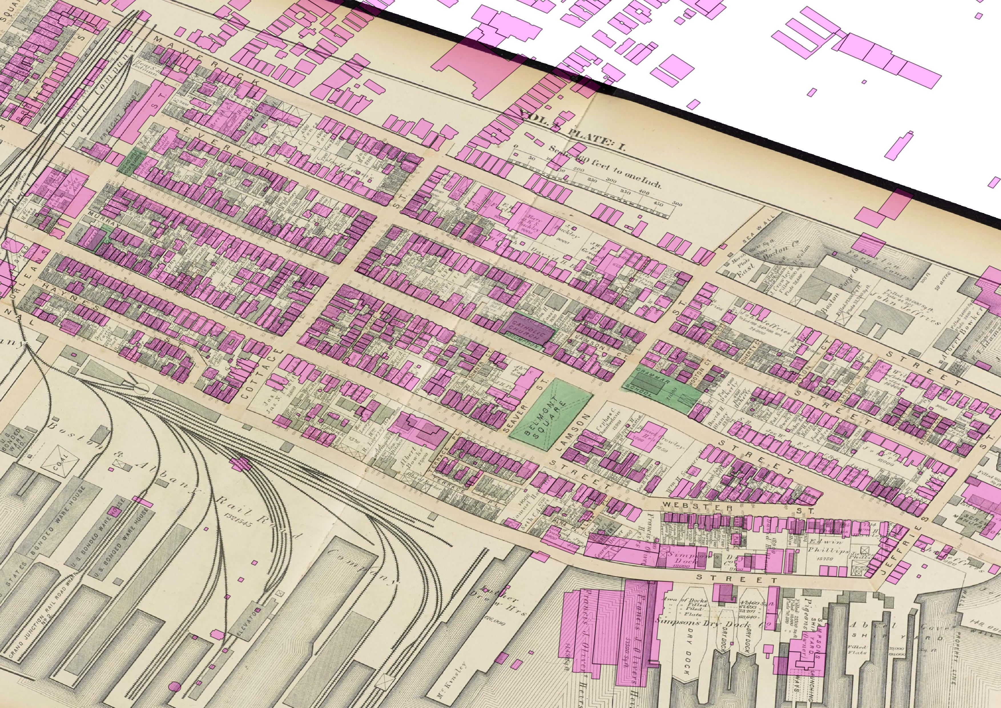
The shipbuilding boom also brought a new level of prosperity to Jeffries Point. The hilltop area surrounding Belmont Square has long been considered one of East Boston’s most desirable residential enclaves, and during the clippership era, it was home to some of East Boston’s wealthiest residents, including Samuel Hall, the first shipbuilder to move to East Boston and one of the most famous clippership builders of his day, who lived in the grand townhouse that still stands at 199 Webster Street. By 1874, some of the neighborhood’s largest houses had been built around Belmont Square. In another sign of the area’s exclusivity, many of these houses feature generous street setbacks and large side and rear yards, making the area noticeably less dense than the areas of working and middle class housing that surround it.
By 1870, the clippership boom had begun to collapse. Clipperships sacrifice cargo space for speed, and as technological and economic conditions shifted, this tradeoff no longer made sense. Railroads, which crisscrossed the country by 1870, offered fast, reliable cargo transportation, and the shipping industry was increasingly dominated by large, iron steamships. As the age of wooden sailing ships drew to a close, more than half of the workers who had been employed by East Boston shipyards left the neighborhood.
Despite this mass exodus, the neighborhood continued to expand. Although some of the old shipyards took on ship repair work and new machine shops and iron foundries opened along the waterfront to support the new iron shipbuilding industry, the neighborhood’s industrial economy would never fully recover. Instead, by the late 19th century, the primary driver of growth in the neighborhood was immigration.
In the 1840s, the Cunard Line built its first American passenger ship terminal on the Jeffries Point waterfront. Over the course of the late 19th and early 20th centuries, thousands of European immigrants arrived at the Cunard Terminal in Jeffries Point, and many of them chose to settle in the neighborhood.
Immigrants from England, Ireland, and Canada were the first to arrive, but by 1874, an increasing number of immigrants were from southern and eastern Europe. Looking at the 1874 map, the most obvious evidence of this surge in European immigration is the Catholic Church of the Assumption, built around 1870 just north of Belmont Square to serve the rapidly expanding Catholic immigrant community. As the population of the neighborhood grew, developers continued building new housing. By the early 20th century, very few open lots remained in Jeffries Point.
We often think of globalization as a new phenomenon. But for its entire 180-year history, Jeffries Point has been shaped by global forces. The neighborhood flourished early on thanks to the discovery of gold 3000 miles away in California. And for nearly a century-and-a-half, Jeffries Point has continued to grow and reinvent itself as thousands of immigrants from across the globe have made homes in the neighborhood. This legacy lives on in the neighborhood’s buildings and streetscapes – because residents chose to preserve and adapt existing buildings rather than demolish and replace them, the vast majority of buildings ever constructed in Jeffries Point are still standing today.
I’ll leave you with the 1874 map of Jeffries Point with current buildings overlaid in pink (click to expand). As you can see, most of the neighborhood’s 19th century buildings still exist today. But what did these buildings look like when they were built? And what do they look like today? Check back next time to find out.
This post is part of a series about the process of nominating my neighborhood for the National Register of Historic Places. To see all of the posts in the series, click here.


This is amazing info I been living at 42 jeffries st 54 yrs an my mom been here84 yrs An her na was here since 1930 an 40 jeffries my moms mom had a store called Anna’s coffee shop an most of the ship yard gave the bus an the neighbors 551 sumner was my cuzins house near my he jp Yaught club an going up the st from 551 to was my dads family’s s house the were from Sisley I grew up down this section privileged, in the 70’s my mom had the city put sand down next to the yaught club. An we called it the wharf we grew up there are own little beach an in the summer we had 4th of July races the whole neighborhood this section was called the first sec back in the day An down near the tennis courts was a boat yard called tringalies bias yard honestly it was so amazing here everyone knew each other an every corner we all sat in front of our houses in the summer till1 am having coffee etc, it’s just a memory that I will cherish be so thankful,
Thanks for the comment. It’s great hearing about how the neighborhood has changed over the years from longtime residents. I didn’t realize that people still called this area ‘the first section’ as recently as the 70s — that was what the East Boston Company named it in 1833! I kind of wish there was still a beach down by the Yacht Club, that sounds like a lot of fun.
Others, who remember that beach call it ‘the Sandies’. Around the corner, along Marginal Street, at what I believe was once the Navy Fuel Pier, old Marginal Street residents called that beach “Simpson’s Beach”. It was just a few parcels down from Simpson’s Dry Dock, which was located in what is now that strange concrete water area directly across from KO Pies.