This post is part of a series about the process of nominating my neighborhood for the National Register of Historic Places. To see all of the posts in the series, click here.
Last time, we looked at Then and Now photos showing the Samuel Hall house, one of Jeffries Point’s grandest houses, and a run of worker housing along the neighborhood’s waterfront. Both images give a sense of how Jeffries Point’s housing has changed over the past century. Today, let’s check out some of the neighborhood’s public spaces: a former library branch, a church, and a neighborhood streetscape. Use the slider in the center of each image to compare past and present photos.
Jeffries Point Library Branch
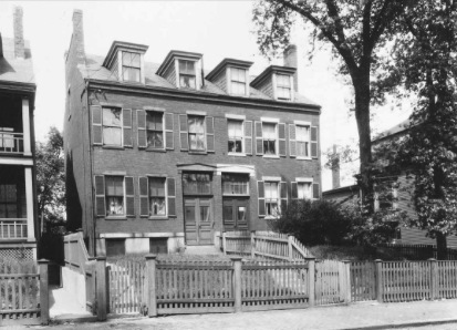

Left: pre-1930 | Right: 2017
This handsome brick house was built in the 1840s, making it one of the oldest houses in East Boston. It began life as a double house – two side-by-side houses that share a central wall – with Greek Revival architectural details and paired front doors at the center. In the 1930s, it was converted to a neighborhood library branch – just one example of the many ways that the East Boston community has adapted and reused existing buildings to better suit their needs over the years.
As part of its conversion to a library, the building was remodeled. The dormer windows were removed from the roof, and the front entrance was shifted to the left. Georgian Revival architectural details – the arched front entrance and fan light – were introduced to the building at this time. These alterations were done in a seamless way, so that today, it’s easy to mistake the building for a much older Georgian or Federal style house. The library branch closed in the mid-20th century and the building was again converted back to a two-family home, which it remains to this day.
Church of the Assumption
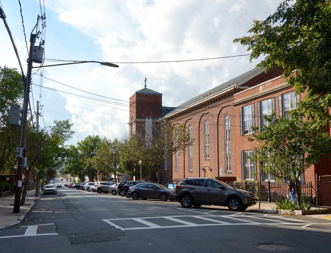
Left: 2017 | Right: ca. 1905
The Catholic Church of the Assumption was built in 1870 to serve Jeffries Point’s growing Catholic immigrant population. It sits at the opposite corner of Belmont Square from the Samuel Hall house. The church was designed by Irish-American architect Patrick Keely, who designed over 600 churches, most of them in New York and New England, during his career. His work includes Boston’s Cathedral of the Holy Cross.
In the 1940s, a fire destroyed the steeple and the rectory (visible to the right of the church in the 1905 photograph). When the steeple was repaired, it was squared off and shortened. The old rectory was replaced with a new blockier, less ornate one.
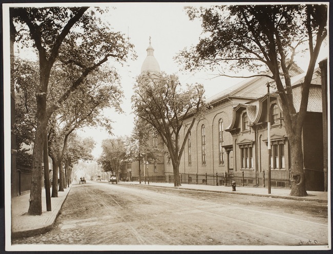
Webster Street
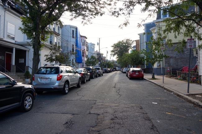
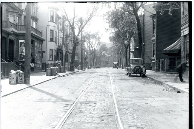
Left: 2017 | Right: ca. 1935
The stretch of Webster Street seen here shows how Jeffries Point’s streets have changed over the years. In 1935, a number of storefronts had been created along Webster Street on the ground floors of the street’s formerly single-family townhouses. As East Boston’s population reached a high point of nearly 65,000 residents in the early 20th century, there was a proliferation of shops and storefronts along neighborhood streets that, today, are almost exclusively residential. Demand for shops close to home was driven by a higher population density and a lack of convenient transportation options in a time before cars were common.
Speaking of cars, one of the most striking things about the 1935 photo of Webster Street is the almost complete lack of parked cars. When East Boston’s streets were laid out in 1833, the neighborhood’s planners went to great lengths to ensure that the streets were straight and wide. It was a sharp departure from the unplanned, winding streets around which downtown Boston grew. In contrast, East Boston’s street plan was considered grand and modern when it was created. Even so, the streets were designed for pedestrians and horse-drawn carts and carriages, and most of the neighborhood’s streets were unpaved until the very end of the 19th century.
As new transportation options became available, the city and the East Boston community adapted and updated the neighborhood’s streets. First, horse-drawn omnibuses, and later electric trolleys, were introduced – you can see the rails in the center of the street in the 1935 photo above. In 1935, Webster Street was in the midst of transition – the street’s trolley line was still running, but the handful of cars parked along the sides of the street were a sign of things to come. Over the course of the 20th century, East Boston’s trolley lines disappeared, and the neighborhood’s streets came to be dominated by cars. But in 1935, it’s still possible to see the East Boston planner’s original vision of a neighborhood of wide, grand streets. Today, with parked cars lining the neighborhood’s streets, most have been reduced to narrow, one-way lanes.
My husband and his brothers grew up in the point. Love the information you post.
Thanks, glad you’re enjoying it!
The first thing I noticed about the photos of the church and Webster St. was how much more pleasant and open the streets looked without being clogged by cars. There’s room to breath and feel relaxed, not wary of being run over. Well, we’ll never regain that aspect … but it’s great to see how many buildings still survive. They don’t necessarily look the same, but then, neither do I!
It’s a pretty amazing difference isn’t it? Streets that were designed to be open and airy now feel claustrophobic with all the parked cars. But you never know, maybe self-driving (and self-parking) cars will lead to the disappearance of street parking sometime in the near future.
I lived and looked down the Sumner St / Seaver St corner for 33 years.. seeing Assumption Church and trying to see Dozzi’s or (Sandies) what sub shop was called in 80’s… Love that photo and thank you for bringing me right back home again….keep up the great work..